Sahara desert
|
The name Sahara derives from the Arabic noun ṣaḥrāʾ, meaning
desert, and its plural, ṣaḥārāʾ. It is also related to the adjective aṣḥar,
meaning desertlike and carrying a strong connotation of the reddish colour of
the vegetationless plains. There are also indigenous names for particular
areas—such as the Tanezrouft region of southwestern Algeria and the Ténéré
region of central Niger—which are often of Berber origin.
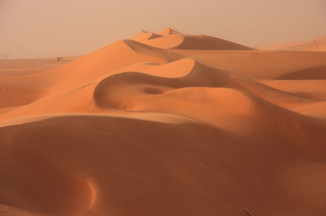
The Sahara sits atop the African Shield, which is composed of heavily folded and denuded Precambrian rocks. Because of the stability of the shield, subsequently deposited Paleozoic formations have remained horizontal and relatively unaltered. Over much of the Sahara, these formations were covered by Mesozoic deposits—including the limestones of Algeria, southern Tunisia, and northern Libya, and the Nubian sandstones of the Libyan Desert—and many of the important regional aquifers are identified with them. In the northern Sahara, these formations are also associated with a series of basins and depressions extending from the oases of western Egypt to the chotts of Algeria. In the southern Sahara, downwarping of the African Shield created large basins occupied by Cenozoic lakes and seas, such as the ancient Mega-Chad. The serirs and regs differ in character in various regions of the desert but are believed to represent Cenozoic depositional surfaces. A prominent feature of the plains is the dark patina of ferromanganese compounds, called desert varnish, that forms on the surfaces of weathered rocks. The plateaus of the Sahara, such as the Tademaït Plateau of Algeria, are typically covered with angular, weathered rock. In the central Sahara, the monotony of the plains and plateaus is broken by prominent volcanic massifs—including Mount ʿUwaynat and the Tibesti and Ahaggar mountains. Other noteworthy formations include the Ennedi Plateau of Chad, the Aïr Massif of Niger, the Iforas Massif of Mali, and the outcroppings of the Mauritanian Adrar region. Sand sheets and dunes cover approximately 25 percent of the Sahara’s surface. The principal types of dunes include tied dunes, which form in the lee of hills or other obstacles; parabolic blowout dunes; crescent-shaped barchans and transverse dunes; longitudinal seifs; and the massive, complex forms associated with sand seas. Several pyramidal dunes in the Sahara attain heights of nearly 500 feet, while draa, the mountainous sand ridges that dominate the ergs, are said to reach 1,000 feet. An unusual phenomenon associated with desert sands is their “singing” or booming. Various hypotheses have been advanced to explain the phenomenon, such as those based upon the piezoelectric property of crystalline quartz, but the mystery remains unsolved. |
Sahara Desert
|
Namib Desert
|
The coastal area is almost totally rainless, yet its air is almost always at or near the saturation point. The cold Benguela Current flows northward along the coast, chilling the air above it and thus producing fog. This cool air moves inland as a southwest sea breeze, creating a temperature inversion about 1,000 feet (300 meters) thick, with fog below and hot, dry air above.
At the coast there is little difference in temperature between day and night or between winter and summer. Temperatures are usually between 50 and 60 °F (10 and 16 °C). Along the inland margins, summer temperatures normally reach the upper 80s F (low 30s C). Only in areas sheltered from the cooling sea breeze (lee sides of mountains and bottoms of canyons) do temperatures frequently approach those expected in low-latitude deserts—i.e., in excess of 100 °F (38 °C). Freezing temperatures occur occasionally along the inner edge of the desert. A few days each year, usually in fall or spring, berg (mountain) winds blowing from the east bring high temperatures (above 100 °F), together with dry air and clouds of dust, across the desert to the coast itself. The rare rains occur usually as short-lived torrential thunderstorms. Average annual precipitation is generally about 0.5 inch (13 mm) at the coast, increasing inland until it reaches 2 inches (51 mm) at the foot of the escarpment. In some years, however, no rain falls at all. Dew, on the other hand, is heavy and for some types of vegetation is more important than the rainfall. In the extreme south, some winter precipitation occurs from frontal storms passing farther south over the Cape region; on rare occasions, snow may fall on the higher southern mountains. Kalahari Desert
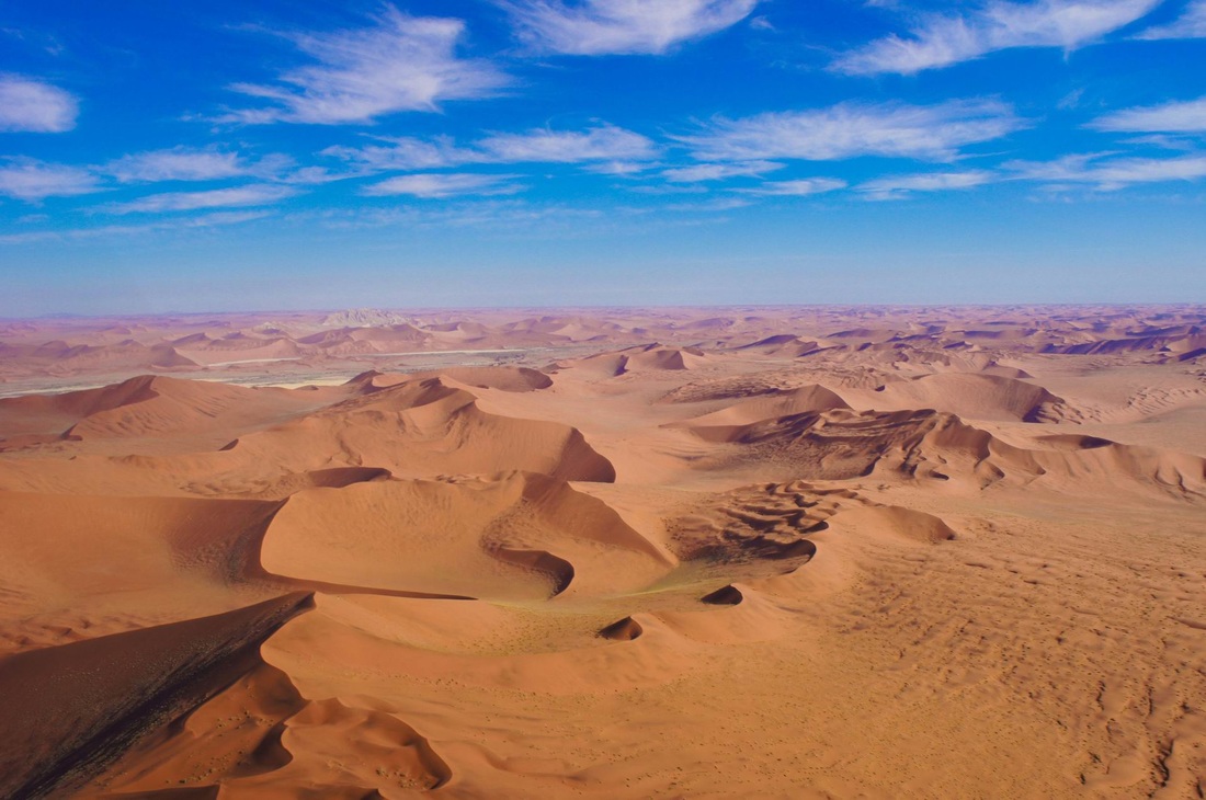
The Kalahari is a featureless, gently undulating, sand-covered plain, which everywhere is 3,000 feet (900 metres) or more above sea level. Bedrock is exposed only in the low but vertical-walled hills, called kopjes, that rarely but conspicuously rise above the general surface. Aside from the kopjes, three surfaces characterize virtually all of the Kalahari: sand sheets, longitudinal dunes, and vleis (pans).
The sand sheets appear to have been formed during the Pleistocene Epoch (about 2,600,000 to 11,700 years ago), and they have been fixed in place since then. In some areas they appear to have been of fluvial origin, the result of sheet flooding in times of much greater precipitation, but by far the greater part of them were wind-formed. The sheets occupy the eastern part of the Kalahari. Their surface elevation varies only slightly, with relief measured in tens of feet per mile. The depth of the sand there generally exceeds 200 feet. In many areas the sand is red, the result of a thin layer of iron oxide that coats the grains of sand. The entire western Kalahari is characterized by long chains of dunes, oriented roughly to the north or northwest. The dunes measure at least 1 mile in length, several hundred feet in width, and 20 to 200 feet in height. Each dune is separated from its neighbour by a broad parallel depression locally called a straat (“street,” or “lane”), because each constitutes the easy way to travel. Vleis, or pans are the terminal features of desert drainage systems, the “dry lakes” at the end of ephemeral streams. Many are remnant features from an earlier period of greater precipitation. Very little water ever flowed to the sea from the Kalahari. Rather, each stream ended its course in a slightly lower depression from which there was no outlet. There, as the stream dried up, the fine silt particles carried in suspension by the sluggish stream were deposited along with soluble calcium minerals and salts precipitated out of the evaporating water. The results are pans—flat surfaces devoid of vegetation that are gleaming white when dry, hardened by the cementing action of the soluble minerals, and, on occasion, covered by a shallow layer of standing water. Where the salt content is low, pans may become covered with grasses after a rain. 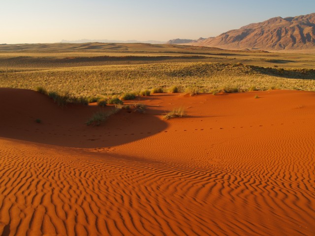
Kalahari Desert
|
Namib Desert
|
